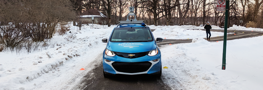
Self-Driving Vehicles
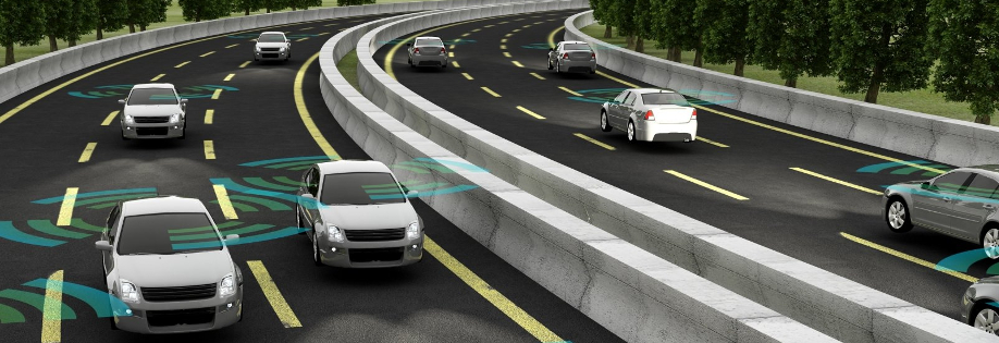
As part of the SAE Autodrive Challenge, students in our lab will be working on designing, developing, and testing a self-driving car over the next three years. This will require the students to create solutions to problems such as Localization & Mapping, Pose Estimation, Lane & Road keeping, and Obstacle Detection & Tracking. The team will be receiving a Chevrolet Bolt EV from GM as well as several state-of-the art sensors as part of the competition sponsorship. More information of the team’s progress can found on their website and Facebook page.
Related Publications
Robots need to predict and react to human motions to navigate through a crowd without collisions. Many existing methods decouple prediction from planning, which does not account for the interaction between robot and human motions and can lead to the robot getting stuck. We propose SICNav, a Model Predictive Control (MPC) method that jointly solves for robot motion and predicted crowd motion in closed-loop. We model each human in the crowd to be following an Optimal Reciprocal Collision Avoidance (ORCA) scheme and embed that model as a constraint in the robot’s local planner, resulting in a bilevel nonlinear MPC optimization problem. We use a KKT-reformulation to cast the bilevel problem as a single level and use a nonlinear solver to optimize. Our MPC method can influence pedestrian motion while explicitly satisfying safety constraints in a single-robot multi-human environment. We analyze the performance of SICNav in two simulation environments and indoor experiments with a real robot to demonstrate safe robot motion that can influence the surrounding humans. We also validate the trajectory forecasting performance of ORCA on a human trajectory dataset. Code: https://github.com/sepsamavi/safe-interactive-crowdnav.git.
@ARTICLE{samavi-tro23,
title = {{SICNav}: Safe and Interactive Crowd Navigation using Model Predictive Control and Bilevel Optimization},
author = {Sepehr Samavi and James R. Han and Florian Shkurti and Angela P. Schoellig},
journal = {{IEEE Transactions on Robotics}},
year = {2024},
urllink = {https://arxiv.org/abs/2310.10982},
doi = {10.1109/TRO.2024.3484634},
abstract = {Robots need to predict and react to human motions to navigate through a crowd without collisions. Many existing methods decouple prediction from planning, which does not account for the interaction between robot and human motions and can lead to the robot getting stuck. We propose SICNav, a Model Predictive Control (MPC) method that jointly solves for robot motion and predicted crowd motion in closed-loop. We model each human in the crowd to be following an Optimal Reciprocal Collision Avoidance (ORCA) scheme and embed that model as a constraint in the robot's local planner, resulting in a bilevel nonlinear MPC optimization problem. We use a KKT-reformulation to cast the bilevel problem as a single level and use a nonlinear solver to optimize. Our MPC method can influence pedestrian motion while explicitly satisfying safety constraints in a single-robot multi-human environment. We analyze the performance of SICNav in two simulation environments and indoor experiments with a real robot to demonstrate safe robot motion that can influence the surrounding humans. We also validate the trajectory forecasting performance of ORCA on a human trajectory dataset. Code: https://github.com/sepsamavi/safe-interactive-crowdnav.git.}
} ![]() Boreas: a multi-season autonomous driving datasetK. Burnett, D. J. Yoon, Y. Wu, A. Z. Li, H. Zhang, S. Lu, J. Qian, W. Tseng, A. Lambert, K. Y. K. Leung, A. P. Schoellig, and T. D. BarfootThe International Journal of Robotics Research, vol. 42, iss. 1-2, p. 33–42, 2023.
Boreas: a multi-season autonomous driving datasetK. Burnett, D. J. Yoon, Y. Wu, A. Z. Li, H. Zhang, S. Lu, J. Qian, W. Tseng, A. Lambert, K. Y. K. Leung, A. P. Schoellig, and T. D. BarfootThe International Journal of Robotics Research, vol. 42, iss. 1-2, p. 33–42, 2023.
![]()
![]()
![]()
The Boreas dataset was collected by driving a repeated route over the course of one year, resulting in stark seasonal variations and adverse weather conditions such as rain and falling snow. In total, the Boreas dataset contains over 350km of driving data featuring a 128-channel Velodyne Alpha-Prime lidar, a 360 degree Navtech CIR304-H scanning radar, a 5MP FLIR Blackfly S camera, and centimetre-accurate post-processed ground truth poses. At launch, our dataset will support live leaderboards for odometry, metric localization, and 3D object detection. The dataset and development kit are available at: https://www.boreas.utias.utoronto.ca/
@article{burnett-ijrr22,
author = {Keenan Burnett and David J. Yoon and Yuchen Wu and Andrew Zou Li and Haowei Zhang and Shichen Lu and Jingxing Qian and Wei-Kang Tseng and Andrew Lambert and Keith Y.K. Leung and Angela P. Schoellig and Timothy D. Barfoot},
title = {Boreas: A Multi-Season Autonomous Driving Dataset},
journal = {{The International Journal of Robotics Research}},
volume = {42},
number = {1-2},
pages = {33--42},
year = {2023},
doi = {10.1177/02783649231160195},
abstract = {The Boreas dataset was collected by driving a repeated route over the course of one year, resulting in stark seasonal variations and adverse weather conditions such as rain and falling snow. In total, the Boreas dataset contains over 350km of driving data featuring a 128-channel Velodyne Alpha-Prime lidar, a 360 degree Navtech CIR304-H scanning radar, a 5MP FLIR Blackfly S camera, and centimetre-accurate post-processed ground truth poses. At launch, our dataset will support live leaderboards for odometry, metric localization, and 3D object detection. The dataset and development kit are available at: https://www.boreas.utias.utoronto.ca/}
} ![]() Does unpredictability influence driving behavior?S. Samavi, F. Shkurti, and A. P. Schoelligin Proc. of the IEEE/RSJ International Conference on Intelligent Robots and Systems (IROS), 2023, p. 1720–1727.
Does unpredictability influence driving behavior?S. Samavi, F. Shkurti, and A. P. Schoelligin Proc. of the IEEE/RSJ International Conference on Intelligent Robots and Systems (IROS), 2023, p. 1720–1727.
![]()
![]()
![]()
In this paper we investigate the effect of the unpredictability of surrounding cars on an ego-car performing a driving maneuver. We use Maximum Entropy Inverse reinforcement Learning to model reward functions for an ego-car conducting a lane change in a highway setting. We define a new feature based on the unpredictability of surrounding cars and use it in the reward function. We learn two reward functions from human data: a baseline and one that incorporates our defined unpredictability feature, then compare their performance with a quantitative and qualitative evaluation. Our evaluation demonstrates that incorporating the unpredictability feature leads to a better fit of human-generated test data. These results encourage further investigation of the effect of unpredictability on driving behavior.
@inproceedings{samavi-iros23,
author={Sepehr Samavi and Florian Shkurti and Angela P. Schoellig},
booktitle={{Proc. of the IEEE/RSJ International Conference on Intelligent Robots and Systems (IROS)}},
title={Does Unpredictability Influence Driving Behavior?},
year={2023},
pages={1720--1727},
doi={10.1109/IROS55552.2023.10342534},
abstract={In this paper we investigate the effect of the unpredictability of surrounding cars on an ego-car performing a driving maneuver. We use Maximum Entropy Inverse reinforcement Learning to model reward functions for an ego-car conducting a lane change in a highway setting. We define a new feature based on the unpredictability of surrounding cars and use it in the reward function. We learn two reward functions from human data: a baseline and one that incorporates our defined unpredictability feature, then compare their performance with a quantitative and qualitative evaluation. Our evaluation demonstrates that incorporating the unpredictability feature leads to a better fit of human-generated test data. These results encourage further investigation of the effect of unpredictability on driving behavior.}
} ![]() Are we ready for radar to replace lidar in all-weather mapping and localization?K. Burnett, Y. Wu, D. J. Yoon, A. P. Schoellig, and T. D. BarfootIEEE Robotics and Automation Letters, vol. 4, iss. 7, p. 10328–10335, 2022.
Are we ready for radar to replace lidar in all-weather mapping and localization?K. Burnett, Y. Wu, D. J. Yoon, A. P. Schoellig, and T. D. BarfootIEEE Robotics and Automation Letters, vol. 4, iss. 7, p. 10328–10335, 2022.
![]()
![]()
![]()
![]()
We present an extensive comparison between three topometric localization systems: radar-only, lidar-only, and a cross-modal radar-to-lidar system across varying seasonal and weather conditions using the Boreas dataset. Contrary to our expectations, our experiments showed that our lidar-only pipeline achieved the best localization accuracy even during a snowstorm. Our results seem to suggest that the sensitivity of lidar localization to moderate precipitation has been exaggerated in prior works. However, our radar-only pipeline was able to achieve competitive accuracy with a much smaller map. Furthermore, radar localization and radar sensors still have room to improve and may yet prove valuable in extreme weather or as a redundant backup system. Code for this project can be found at: https://github.com/utiasASRL/vtr3
@article{burnett-ral22,
author={Keenan Burnett and Yuchen Wu and David J. Yoon and Angela P. Schoellig and Timothy D. Barfoot},
title={Are We Ready for Radar to Replace Lidar in All-Weather Mapping and Localization?},
journal = {{IEEE Robotics and Automation Letters}},
year = {2022},
volume = {4},
number = {7},
pages = {10328--10335},
doi = {10.1109/LRA.2022.3192885},
urllink = {https://ieeexplore.ieee.org/abstract/document/9835037/},
abstract = {We present an extensive comparison between three topometric localization systems: radar-only, lidar-only, and a cross-modal radar-to-lidar system across varying seasonal and weather conditions using the Boreas dataset. Contrary to our expectations, our experiments showed that our lidar-only pipeline achieved the best localization accuracy even during a snowstorm. Our results seem to suggest that the sensitivity of lidar localization to moderate precipitation has been exaggerated in prior works. However, our radar-only pipeline was able to achieve competitive accuracy with a much smaller map. Furthermore, radar localization and radar sensors still have room to improve and may yet prove valuable in extreme weather or as a redundant backup system. Code for this project can be found at: https://github.com/utiasASRL/vtr3}
} ![]() Do we need to compensate for motion distortion and Doppler effects in spinning radar navigation?K. Burnett, A. P. Schoellig, and T. D. BarfootIEEE Robotics and Automation Letters, vol. 6, iss. 2, p. 771–778, 2021.
Do we need to compensate for motion distortion and Doppler effects in spinning radar navigation?K. Burnett, A. P. Schoellig, and T. D. BarfootIEEE Robotics and Automation Letters, vol. 6, iss. 2, p. 771–778, 2021.
![]()
![]()
![]()
![]()
In order to tackle the challenge of unfavorable weather conditions such as rain and snow, radar is being revisited as a parallel sensing modality to vision and lidar. Recent works have made tremendous progress in applying spinning radar to odometry and place recognition. However, these works have so far ignored the impact of motion distortion and Doppler effects on spinning-radar-based navigation, which may be significant in the self-driving car domain where speeds can be high. In this work, we demonstrate the effect of these distortions on radar odometry using the Oxford Radar RobotCar Dataset and metric localization using our own data-taking platform. We revisit a lightweight estimator that can recover the motion between a pair of radar scans while accounting for both effects. Our conclusion is that both motion distortion and the Doppler effect are significant in different aspects of spinning radar navigation, with the former more prominent than the latter. Code for this project can be found at: https://github.com/keenan-burnett/yeti_radar_odometry.
@article{burnett-ral21,
title = {Do We Need to Compensate for Motion Distortion and {Doppler} Effects in Spinning Radar Navigation?},
author = {Keenan Burnett and Angela P. Schoellig and Timothy D. Barfoot},
journal = {{IEEE Robotics and Automation Letters}},
year = {2021},
volume = {6},
number = {2},
pages = {771--778},
doi = {10.1109/LRA.2021.3052439},
urllink = {https://ieeexplore.ieee.org/document/9327473},
abstract = {In order to tackle the challenge of unfavorable weather conditions such as rain and snow, radar is being revisited as a parallel sensing modality to vision and lidar. Recent works have made tremendous progress in applying spinning radar to odometry and place recognition. However, these works have so far ignored the impact of motion distortion and Doppler effects on spinning-radar-based navigation, which may be significant in the self-driving car domain where speeds can be high. In this work, we demonstrate the effect of these distortions on radar odometry using the Oxford Radar RobotCar Dataset and metric localization using our own data-taking platform. We revisit a lightweight estimator that can recover the motion between a pair of radar scans while accounting for both effects. Our conclusion is that both motion distortion and the Doppler effect are significant in different aspects of spinning radar navigation, with the former more prominent than the latter. Code for this project can be found at: https://github.com/keenan-burnett/yeti_radar_odometry.}
} ![]() Self-calibration of the offset between GPS and semantic map frames for robust localizationW. Tseng, A. P. Schoellig, and T. D. Barfootin Proc. of the Conference on Robots and Vision (CRV), 2021, p. 173–180.
Self-calibration of the offset between GPS and semantic map frames for robust localizationW. Tseng, A. P. Schoellig, and T. D. Barfootin Proc. of the Conference on Robots and Vision (CRV), 2021, p. 173–180.
![]()
![]()
![]()
@INPROCEEDINGS{tseng-crv21,
author={Wei-Kang Tseng and Angela P. Schoellig and Timothy D. Barfoot},
booktitle={{Proc. of the Conference on Robots and Vision (CRV)}},
title={Self-Calibration of the Offset Between {GPS} and Semantic Map Frames for Robust Localization},
year={2021},
pages={173--180},
urllink={https://ieeexplore.ieee.org/abstract/document/9469506},
doi={10.1109/CRV52889.2021.00031}
abstract = {In self-driving, standalone GPS is generally considered to have insufficient positioning accuracy to stay in lane. Instead, many turn to LIDAR localization, but this comes at the expense of building LIDAR maps that can be costly to maintain. Another possibility is to use semantic cues such as lane lines and traffic lights to achieve localization, but these are usually not continuously visible. This issue can be remedied by combining semantic cues with GPS to fill in the gaps. However, due to elapsed time between mapping and localization, the live GPS frame can be offset from the semantic map frame, requiring calibration. In this paper, we propose a robust semantic localization algorithm that self-calibrates for the offset between the live GPS and semantic map frames by exploiting common semantic cues, including traffic lights and lane markings. We formulate the problem using a modified Iterated Extended Kalman Filter, which incorporates GPS and camera images for semantic cue detection via Convolutional Neural Networks. Experimental results show that our proposed algorithm achieves decimetre-level accuracy comparable to typical LIDAR localization performance and is robust against sparse semantic features and frequent GPS dropouts.}
}
aUToTrack: a lightweight object detection and tracking system for the SAE AutoDrive challengeK. Burnett, S. Samavi, S. Waslander, T. D. Barfoot, and A. P. Schoelligin Proc. of the Conference on Computer and Robot Vision (CRV), 2019, p. 209–216. Best poster presentation award.
![]()
![]()
![]()
![]()
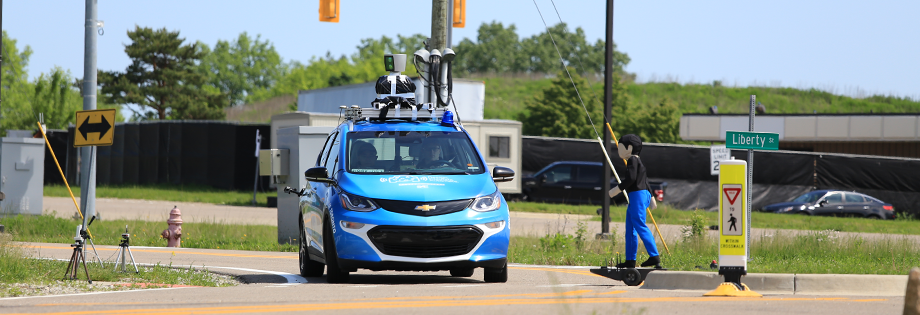
The University of Toronto is one of eight teams competing in the SAE AutoDrive Challenge – a competition to develop a self-driving car by 2020. After placing first at the Year 1 challenge [1], we are headed to MCity in June 2019 for the second challenge. There, we will interact with pedestrians, cyclists, and cars. For safe operation, it is critical to have an accurate estimate of the position of all objects surrounding the vehicle. The contributions of this work are twofold: First, we present a new object detection and tracking dataset (UofTPed50), which uses GPS to ground truth the position and velocity of a pedestrian. To our knowledge, a dataset of this type for pedestrians has not been shown in the literature before. Second, we present a lightweight object detection and tracking system (aUToTrack) that uses vision, LIDAR, and GPS/IMU positioning to achieve state-of-the-art performance on the KITTI Object Tracking benchmark. We show that aUToTrack accurately estimates the position and velocity of pedestrians, in real-time, using CPUs only. aUToTrack has been tested in closed-loop experiments on a real self-driving car (seen in Figure 1), and we demonstrate its performance on our dataset.
@INPROCEEDINGS{burnett-crv19,
author = {Keenan Burnett and Sepehr Samavi and Steven Waslander and Timothy D. Barfoot and Angela P. Schoellig},
title = {{aUToTrack:} A lightweight object detection and tracking system for the {SAE} {AutoDrive} Challenge},
booktitle = {{Proc. of the Conference on Computer and Robot Vision (CRV)}},
year = {2019},
pages = {209--216},
note = {Best poster presentation award},
urlvideo = {https://youtu.be/FLCgcgzNo80},
abstract = {The University of Toronto is one of eight teams competing in the SAE AutoDrive Challenge – a competition to develop a self-driving car by 2020. After placing first at the Year 1 challenge [1], we are headed to MCity in June 2019 for the second challenge. There, we will interact with pedestrians, cyclists, and cars. For safe operation, it is critical to have an accurate estimate of the position of all objects surrounding the vehicle. The contributions of this work are twofold: First, we present a new object detection and tracking dataset (UofTPed50), which uses GPS to ground truth the position and velocity of a pedestrian. To our knowledge, a dataset of this type for pedestrians has not been shown in the literature before. Second, we present a lightweight object detection and tracking system (aUToTrack) that uses vision, LIDAR, and GPS/IMU positioning to achieve state-of-the-art performance on the KITTI Object Tracking benchmark. We show that aUToTrack accurately estimates the position and velocity of pedestrians, in real-time, using CPUs only. aUToTrack has been tested in closed-loop experiments on a real self-driving car (seen in Figure 1), and we demonstrate its performance on our dataset.},
}
Building a winning self-driving car in six monthsK. Burnett, A. Schimpe, S. Samavi, M. Gridseth, C. W. Liu, Q. Li, Z. Kroeze, and A. P. Schoelligin Proc. of the IEEE International Conference on Robotics and Automation (ICRA), 2019, p. 9583–9589.
![]()
![]()
![]()
![]()
![]()
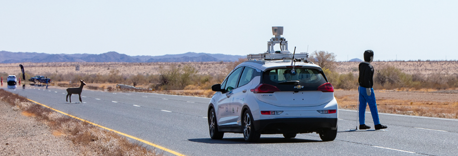
The SAE AutoDrive Challenge is a three-year competition to develop a Level 4 autonomous vehicle by 2020. The first set of challenges were held in April of 2018 in Yuma, Arizona. Our team (aUToronto/Zeus) placed first. In this paper, we describe our complete system architecture and specialized algorithms that enabled us to win. We show that it is possible to develop a vehicle with basic autonomy features in just six months relying on simple, robust algorithms. We do not make use of a prior map. Instead, we have developed a multi-sensor visual localization solution. All of our algorithms run in real-time using CPUs only. We also highlight the closed-loop performance of our system in detail in several experiments.
@INPROCEEDINGS{burnett-icra19,
author = {Keenan Burnett and Andreas Schimpe and Sepehr Samavi and Mona Gridseth and Chengzhi Winston Liu and Qiyang Li and Zachary Kroeze and Angela P. Schoellig},
title = {Building a Winning Self-Driving Car in Six Months},
booktitle = {{Proc. of the IEEE International Conference on Robotics and Automation (ICRA)}},
year = {2019},
pages = {9583--9589},
urlvideo = {http://tiny.cc/zeus-y1},
urllink = {https://arxiv.org/abs/1811.01273},
abstract = {The SAE AutoDrive Challenge is a three-year competition to develop a Level 4 autonomous vehicle by 2020. The first set of challenges were held in April of 2018 in Yuma, Arizona. Our team (aUToronto/Zeus) placed first. In this paper, we describe our complete system architecture and specialized algorithms that enabled us to win. We show that it is possible to develop a vehicle with basic autonomy features in just six months relying on simple, robust algorithms. We do not make use of a prior map. Instead, we have developed a multi-sensor visual localization solution. All of our algorithms run in real-time using CPUs only. We also highlight the closed-loop performance of our system in detail in several experiments.},
} ![]() Robust constrained learning-based NMPC enabling reliable mobile robot path trackingC. J. Ostafew, A. P. Schoellig, and T. D. BarfootInternational Journal of Robotics Research, vol. 35, iss. 13, pp. 1547-1563, 2016.
Robust constrained learning-based NMPC enabling reliable mobile robot path trackingC. J. Ostafew, A. P. Schoellig, and T. D. BarfootInternational Journal of Robotics Research, vol. 35, iss. 13, pp. 1547-1563, 2016.
![]()
![]()
![]()
![]()
This paper presents a Robust Constrained Learning-based Nonlinear Model Predictive Control (RC-LB-NMPC) algorithm for path-tracking in off-road terrain. For mobile robots, constraints may represent solid obstacles or localization limits. As a result, constraint satisfaction is required for safety. Constraint satisfaction is typically guaranteed through the use of accurate, a priori models or robust control. However, accurate models are generally not available for off-road operation. Furthermore, robust controllers are often conservative, since model uncertainty is not updated online. In this work our goal is to use learning to generate low-uncertainty, non-parametric models in situ. Based on these models, the predictive controller computes both linear and angular velocities in real-time, such that the robot drives at or near its capabilities while respecting path and localization constraints. Localization for the controller is provided by an on-board, vision-based mapping and navigation system enabling operation in large-scale, off-road environments. The paper presents experimental results, including over 5 km of travel by a 900 kg skid-steered robot at speeds of up to 2.0 m/s. The result is a robust, learning controller that provides safe, conservative control during initial trials when model uncertainty is high and converges to high-performance, optimal control during later trials when model uncertainty is reduced with experience.
@ARTICLE{ostafew-ijrr16,
author = {Chris J. Ostafew and Angela P. Schoellig and Timothy D. Barfoot},
title = {Robust Constrained Learning-Based {NMPC} Enabling Reliable Mobile Robot Path Tracking},
year = {2016},
journal = {{International Journal of Robotics Research}},
volume = {35},
number = {13},
pages = {1547-1563},
doi = {10.1177/0278364916645661},
url = {http://dx.doi.org/10.1177/0278364916645661},
eprint = {http://dx.doi.org/10.1177/0278364916645661},
urlvideo = {https://youtu.be/3xRNmNv5Efk},
abstract = {This paper presents a Robust Constrained Learning-based Nonlinear Model Predictive Control (RC-LB-NMPC) algorithm for path-tracking in off-road terrain. For mobile robots, constraints may represent solid obstacles or localization limits. As a result, constraint satisfaction is required for safety. Constraint satisfaction is typically guaranteed through the use of accurate, a priori models or robust control. However, accurate models are generally not available for off-road operation. Furthermore, robust controllers are often conservative, since model uncertainty is not updated online. In this work our goal is to use learning to generate low-uncertainty, non-parametric models in situ. Based on these models, the predictive controller computes both linear and angular velocities in real-time, such that the robot drives at or near its capabilities while respecting path and localization constraints. Localization for the controller is provided by an on-board, vision-based mapping and navigation system enabling operation in large-scale, off-road environments. The paper presents experimental results, including over 5 km of travel by a 900 kg skid-steered robot at speeds of up to 2.0 m/s. The result is a robust, learning controller that provides safe, conservative control during initial trials when model uncertainty is high and converges to high-performance, optimal control during later trials when model uncertainty is reduced with experience.},
} ![]() Speed daemon: experience-based mobile robot speed schedulingC. J. Ostafew, A. P. Schoellig, T. D. Barfoot, and J. Collierin Proc. of the International Conference on Computer and Robot Vision (CRV), 2014, pp. 56-62. Best Robotics Paper Award.
Speed daemon: experience-based mobile robot speed schedulingC. J. Ostafew, A. P. Schoellig, T. D. Barfoot, and J. Collierin Proc. of the International Conference on Computer and Robot Vision (CRV), 2014, pp. 56-62. Best Robotics Paper Award.
![]()
![]()
![]()
![]()
A time-optimal speed schedule results in a mobile robot driving along a planned path at or near the limits of the robot’s capability. However, deriving models to predict the effect of increased speed can be very difficult. In this paper, we present a speed scheduler that uses previous experience, instead of complex models, to generate time-optimal speed schedules. The algorithm is designed for a vision-based, path-repeating mobile robot and uses experience to ensure reliable localization, low path-tracking errors, and realizable control inputs while maximizing the speed along the path. To our knowledge, this is the first speed scheduler to incorporate experience from previous path traversals in order to address system constraints. The proposed speed scheduler was tested in over 4 km of path traversals in outdoor terrain using a large Ackermann-steered robot travelling between 0.5 m/s and 2.0 m/s. The approach to speed scheduling is shown to generate fast speed schedules while remaining within the limits of the robot’s capability.
@INPROCEEDINGS{ostafew-crv14,
author = {Chris J. Ostafew and Angela P. Schoellig and Timothy D. Barfoot and J. Collier},
title = {Speed daemon: experience-based mobile robot speed scheduling},
booktitle = {{Proc. of the International Conference on Computer and Robot Vision (CRV)}},
pages = {56-62},
year = {2014},
doi = {10.1109/CRV.2014.16},
urlvideo = {https://youtu.be/Pu3_F6k6Fa4?list=PLC12E387419CEAFF2},
abstract = {A time-optimal speed schedule results in a mobile robot driving along a planned path at or near the limits of the robot's capability. However, deriving models to predict the effect of increased speed can be very difficult. In this paper, we present a speed scheduler that uses previous experience, instead of complex models, to generate time-optimal speed schedules. The algorithm is designed for a vision-based, path-repeating mobile robot and uses experience to ensure reliable localization, low path-tracking errors, and realizable control inputs while maximizing the speed along the path. To our knowledge, this is the first speed scheduler to incorporate experience from previous path traversals in order to address system constraints. The proposed speed scheduler was tested in over 4 km of path traversals in outdoor terrain using a large Ackermann-steered robot travelling between 0.5 m/s and 2.0 m/s. The approach to speed scheduling is shown to generate fast speed schedules while remaining within the limits of the robot's capability.},
note = {Best Robotics Paper Award}
}